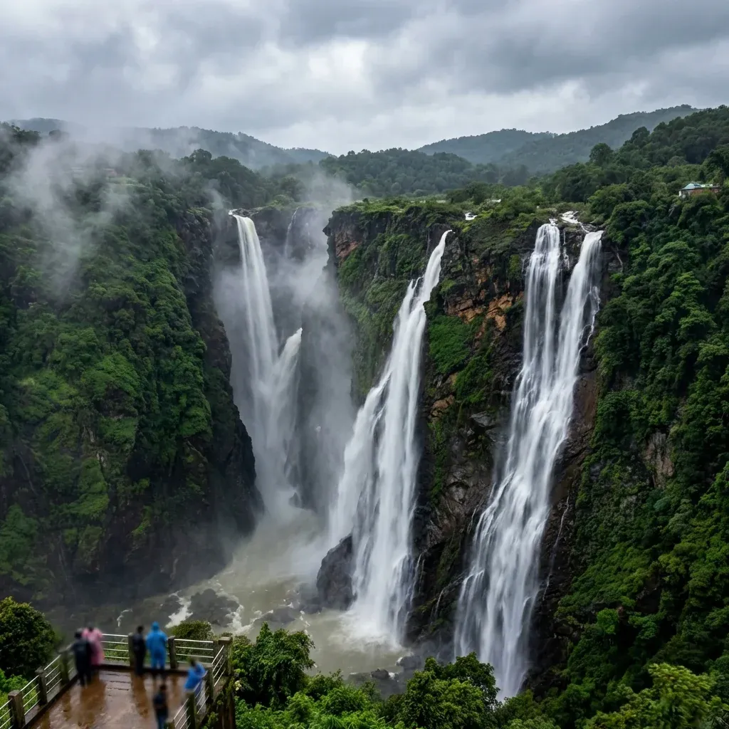
Located deep within Shivamogga District, Karnataka, Jog Falls plunges a staggering 253 meters (830 feet) directly down a rocky chasm. Carved by the Sharavathi River, it holds the title as India's second-highest plunge waterfall, completely unsegmented by terraced rocks.
Jog Falls
The Mighty Four-Tiered Cascade of the Sharavathi River
A Glimpse into History
Origins – Natural Geological Fault
The incredible sheer drop was naturally formed by massive ancient geological faulting in the Western Ghats. The forceful Sharavathi river sliced perfectly through the granite bedrock creating four distinct tracks down the cliff.
Evolution – The Four Brothers
Locals accurately named the four separate cascades characterizing their flow: Raja (the unbroken main fall), Roarer (the thunderous middle), Rocket (shooting jets of water), and Rani (the gracefully winding stream).
Modern Era – Hydroelectric Integration
Post-independence, the upstream Linganamakki Dam was constructed to harness unprecedented hydroelectric power. While this severely restricts the waterfall's flow during brutal dry summers, monsoon gates release spectacular torrents.
Significance
Beyond its massive visual tourism draw, the associated Mahatma Gandhi Hydroelectric project fundamentally powered early industrial Karnataka. During peak monsoon discharges, the four distinct falls unite into a colossal, blinding white wall of water generating heavy local fog.
Festivals & Events
Independence Day Illumination (August)
During the height of the monsoon coinciding precisely with national holidays, the surrounding state-operated viewpoints deploy massive halogen lights vividly illuminating the roaring cascade against the pitch-black valley.
Sharavathi Valley Trekking Season (Winter)
Once the heavy monsoons adequately subside, specialized eco-tourism groups legally organize rugged downstream gorge treks exploring the hidden flora strictly accessible only during lower river flows.
Did You Know?
The falls are unique because the water forcefully drops directly to the basin without touching rocks. This specific 'plunge' characteristic creates an immense reverberating thunder heard for kilometres across the valley.
Travel Guide
How to Reach
By Air: Hubballi Airport (HBX) sits roughly 130 km north; Mangaluru (IXE) is 200 km southward.
By Train: Talaguppa Station (~14 km) terminates the line; direct overnight express trains connect seamlessly from Bengaluru.
By Road: Excellent highways (NH 69) navigate directly through Sagara (~30 km); buses drop passengers exactly at the viewpoint gates.
Best Time to Visit
August to October guarantees the absolute roaring spectacle. Visiting strictly between February and May results in extreme disappointment as the falls shrink entirely to thin trickles due to heavy dam retention.
Local Attractions
Linganamakki Dam (~11 km): The colossal structure actively controlling the Sharavathi river flow.
Honnemaradu (~25 km): A stunning backwater reservoir famed for calm kayaking and coracle rides.
Keladi Temple (~35 km): Exquisite ancient wooden and stone architecture remaining from the Keladi Nayaka dynasty.
Tips for Visitors
The 1,400 descending steps to the bottom basin are securely closed during heavy monsoons; obey protective barricades strictly.
Heavy morning mist frequently obliterates visibility entirely; patiently wait until midday for the fog curtain to finally lift.
The enormous wind drafts from the falls push heavy water spray outwards soaking viewers directly; carry robust umbrellas.
Walk across to the British-era 'Watkins Platform' viewpoint to specifically capture front-facing panoramic shots of the falls.
Location Map
Image Gallery